“We had a great day – about 1600 plants in the ground!” was the enthusiastic report from Jim Law after a successful planting day at Wairio Wetland in southern Wairarapa.
Mainly flaxes and sedges (about 1200) were planted around the southern and south eastern sides of the new dam wall at Stage 4 and 400 Totora and cabbage trees planted went in at Stage 2.
A good turn-out included Martinborough School students and staff, Taratahi trainees, Rangitane members, Rotary members, Greater Wellington Regional Council (who provided the sausage sizzle), some Rabobank staff, DOC staff and a few locals plus some co-opted farm workers - about 60 folks in all.
More clover seed was sown on the dam wall at Stage 4 by Ross Cottle and Jim Campbell.
A good year so far at the Wairio Wetland – in total just over 4000 shrubs, flaxes and trees in the ground and a great new dam wall trapping about 30 hectares of water in Stage 4. There is more to come with plans advancing for the reticulation of water from Mathews Lagoon and Boggy Pond into the Wairio Wetland.
In late November Steve Playle did a trap run at Boggy Pond and Wairio. The count was 1 ferret, 1 rat and 10 hedgehogs.
“The ferret was a big bugger and was caught along the stop bank between Mathews and Boggy. This took the total predator count to 23 ferrets, 1 stoat, 2 weasels, 4 cats, 5 rats and 14 hedgehogs.” said Steve.
Rampant growth of grass and weeds along with warm weather meant extra time cleaning around trap sites. Steve also put out another seven DoC250 traps on the Wairio Restoration Block along with two more timms traps along a pine belt where cats have been seen.
Stock tends to interfere with the traps in the Wairio Restoration Block. “We have to live with that unfortunately,” said Steve.
Mice also play havoc with baits with most traps stripped of meat if they have not had a kill in them. Steve said he knows it’s mostly mice because the DoC traps have mouse droppings in them. He has seen mice in the timms traps too. “With only one ferret for this check it could mean their numbers and getting down or maybe they are feasting on mice or even frogs as the place is alive with them at the moment,” said Steve.
Steve has seen and heard bitterns and another was heard at Mathews pond.
Trapping is ongoing.
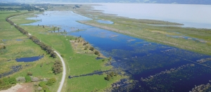
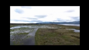
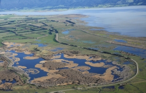
Drone Tour of the Wairio wetlands
Watch the Drone Tour of the wetlands that was created by the Victoria University Research team
Drone view flying over the Wairio Complex
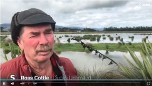
DU President - Video Interview
Well-known journalist, Piers Fuller, interviews DUNZ President Ross Cottle about the history of the celebrated Wairio Wetland development
You can view the video interview here
Victoria University’s classroom in a wetland!
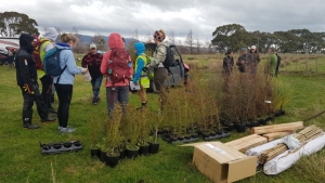
Five years ago, Victoria University Wellington students planted a swathe of nursery trees in the Wairio Wetland.
This landmark wetland habitat was created in the late 1980s by Ducks Unlimited in Collaboration with the Department of Conservation (DOC).
Last week the Victoria University biodiversity team were back. Stephen Hartley and his team were armed with over 300 specimen trees (Kahikatea, Totara, Tawaki (or Swamp) Maire & Cabbage)- sourced thanks to a $2000 grant from DOC - to continue their comparative research into cost effective restoration processes by adding these trees as infill planting.
The cold but enthusiastic University team were supported by members of Ducks Unlimited and DOC.
Tree protection trial
The accompanying photos show Cabbage and Totora trees planted in Grotectors (tree protectors) at Stage 2 in the Wairio Wetland.
They were designed by Don Bell, a DU member who has been involved with the Wairio Restoration Project since its inception. These protectors are being monitored as part of the various plant survival studies being conducted by Victoria University students. It is also hoped to get students from a local secondary school involved in the monitoring process.
As the photos indicate, the plants protected seem to be doing well versus their unprotected neighbours that were similarly planted on spot sprayed sites. In addition to enhancing growth rates, the sheer visibility of the Grotector enables easy follow-up release spraying.
Based on the good results from 2013 the restoration committee decided to use these protectors for the larger plant species this year, especially Kahikatea and Totora.
Rotary support at Wairio
The South Wairarapa Rotary Club (SWRC) recently made a $1600 grant towards the restoration of the Wairio Wetland. The SWRC has contributed $14,480 in total since 2007 – they have been great supporters of this project.
It is one of the long-term environmental projects they support in the South Wairarapa.
In addition to the cash contribution that goes towards the cost of plants (sedges, flaxes and specimen trees, the likes of Totora and Kahikatea) being used in the restoration of the Wetland Rotary members assist in the planting days. It is one way Rotary both contributes to, and participates in community activities. DU certainly appreciate the contributions.
Wet day planting at Wairio Wetland
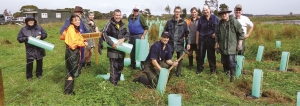
A team of environmental enthusiasts turned up in late April for this year’s first planting at the Wairio Wetland. It was a wet day, great for the plants and not too bad for the enthusiasts but coats were definitely required!
Planters included a great team of young women from Taratahi’s equine school who worked tirelessly in the rain. There were the usual Ducks Unlimited stalwarts and representatives from Greater Wellington Regional Council and Doc. Unfortunately, attendance by teams of students from the local primary schools had to be cancelled because of the wet weather. A GWRC team also put on a BBQ that was most popular once the allotted 650 plants were in the ground.
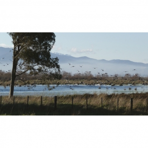
The planting was in a newly fenced off area of Stage 4 along the south eastern fringe of the wetland improved by the construction of a bund wall during 2013. This area has become very popular with local waterfowl with hundreds of ducks, swans and native waders taking flight when the planters arrived. In the years to come waterfowl will be able to fly into a much enhanced wetland as a result of the good work by the planters.
The next planting was July 4. Hope they had a great day.
Ecologists from around New Zealand visited the Wairio wetlands on 29 November with DU President Ross Cottle and Stephen Hartley, of Victoria University, as their tour guides.
The trip was part of the New Zealand Ecological Society’s annual conference in Wellington, and also included a visit to Pounui Lagoon and Onoke Spit, where Denise and Dougal Mackenzie were the guides.
Student Patrick Hipgrave and Dr Stephanie Tomscha spoke about their wetlands projects at the conference.
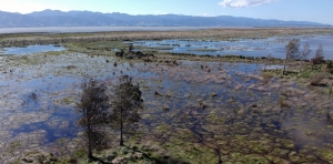
Stephen says Wairio have had good water levels for the past two years and the Raupo beds along the margins of stage 3 and 4 are maturing nicely.
During the tours, several royal spoonbill were spotted as well as the first signs of natural regeneration of Totara and Kahikatea in the drier sections of Stage 3 under restoration plantings of manuka and kohuhu. These were planted in 2011.
The manuka and kohuhu are now more than 3 metres tall and have shaded out the ground cover of tall fescue grass to provide the microsite conditions necessary for successful establishment of totara and kahikatea seedlings
▪ For more information on Dr Tomscha’s project, visit www.victoria.ac.nz
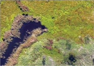
What changes in vegetation cover over time are evident at Wairio?
To what extent is the accuracy of the image classification process improved with the addition of ancillary data?
This project investigates the use of image classification techniques to create detailed maps of wetland areas based on aerial photographs.
The project uses an emerging set of analysis methods called ‘object-based image analysis’ to investigate the applications of remote identification techniques calibrated to detect selected native and invasive species.
An additional objective is to compare and contrast the improvements that including ancillary data into the classification process, such as 3D digital surface models (DSMs) or near infrared imagery, may have over classifications based solely on true-colour images.
The processes being evaluated by this project may allow teams with limited budgets or time to quickly and accurately convert imagery into maps with much greater levels of details, which will improve their ability to detect and track specific plant species.
This is especially useful in the case of wetlands undergoing restoration as they often exhibit significant changes over time, and the target species would normally be challenging to differentiate from one another in an aerial photograph.
Though the study is ongoing, with flights every three months, the initial results would appear to confirm that a ‘true-colour only’ classification would perform poorly compared with ancillary data. The improving effects of including infrared imagery will be tested once that has been gathered.
The classified images contain between 18 and 20 distinct classes.
The Wairio wetland was drained and converted into farmland in the 1960s.
Since 2005, it has been undergoing a managed restoration programme to return it to something approaching its natural state.
Several plantations of native plants have been established, and a weed eradication programme to control invasive species such as Bidens frondosa is in progress. This project can assist this effort by tracking the distribution of natives and weeds.
Object-based image analysis works on the principle that different types of surface cover have unique properties, such as colour, texture or shape.
For instance, weed species might be distinguished from grass as the weeds may be a different shade of green to the surrounding grass, or present a unique textural pattern owing to differently shaped leaves.
The sensors being used in this project are the DJI Phantom 4 Pro Camera, to collect true colour imagery, and a Micasense RedEdge-M, a multispectral sensor for collecting near infrared imagery. The software is ArcGIS Pro 21, ENVI 5.4 and PrecisionMapper 3.32